Showing posts with label Littleton New Hampshire. Show all posts

Tuesday, September 22, 2015

John J. Glessner, Builder of Roads


In September 1915, exactly 100 years ago, a New Hampshire newspaper entitled The Spur published the following short article about the Glessners’ summer estate, The Rocks:

“Every motorist who journeys through the White Mountains comes to know ‘Glessner roads.’  These are the thoroughfares crossing and adjacent to The Rocks, the magnificent estate of J. J. Glessner, of Chicago, between Bethlehem and Littleton, which is regarded as the show place of the hills.  Each road has been placed in fine condition at a cost of much time and personal thought as well as money.  Not a little of the cash expenditure has gone into a substantial wall of cobble stones and granite, four feet high and nearly as thick, which defines the ‘Glessner roads.’  All along the walls shrubs and flowering plants flaunt their colors against the gray background.  The Rocks, which was created by throwing several old farms into one large estate, is stocked with blooded cattle, sheep and hogs and there are also many fowls of high quality.”

The Glessner roads attracted a good deal of attention, and various descriptions of them appear in numerous newspaper articles both in New Hampshire and in Chicago.  Travelers would note that they always knew exactly when they came upon the Glessner estate because of the roads and their beautifully crafted stone walls. 

An article which appeared in The Littleton Courier on October 24, 1907 provided interesting information on the creation of the roads, with a bit of road building history and geology thrown in for good measure.  We reprint it in its entirety.

FINEST IN STATE
The Glessner Roads a Boom to Bethlehem
ARE PUBLIC HIGHWAYS
Rebuilt by Chicago Millionaire in Most Permanent Manner

Two very important pieces of road work have been done in Bethlehem this year, one by the town, taking advantage of the state aid law, and the other by J. J. Glessner, the Chicago millionaire, who has been rebuilding the main highway between Bethlehem and Littleton, for nearly the entire distance where it adjoins his estate.

The work done by the town, in making a ten foot fill at the foot of what is known as the big hill, widening and straightening the road, and taking off some of the grade at the top, has already been described in the Courier.  The work done on the same road by Mr. Glessner is fully as extensive, covers a much longer stretch, and changes a very bad piece of road into one of the finest stretches of highway in the entire state.

In fact during the last few years Mr. Glessner has rapidly been acquiring fame as a road builder.  He is now able to show three miles of probably the finest road in the White Mountains, all within or adjoining his own estate and all public road, although it was all built or built over by Mr. Glessner at his own expense.


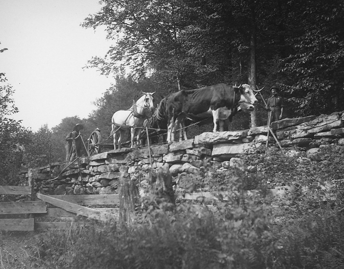
During the present fall he has been working on the half mile of road on the main highway from Bethlehem to Littleton and during most of that time has had a crew of seventy men, thirty horses and twenty oxen engaged on the work.  Part of this road looks like pictures of the modern French or the old Roman roads, and it is built fully as solidly as the Roman roads used to be, in fact, after the same plan.

Macadam and other modern authorities on the building of roads have pronounced Roman methods extravagant, but it is noticed that when the Romans built a road they built one to stay, so that if permanency is considered they were not so extravagant.  Moreover, the use of large amounts of heavy stone is not so extravagant as it might seem on Mr. Glessner’s part, since all of the rock comes out of his own fields.  In fact, for several years he has been cleaning up pastures and making them into mowing land, and the rock that he has pulled out of the pastures has gone back into the roads. 

There is no dearth of rock anywhere in New Hampshire, and certainly not in Bethlehem, nearly all of which is declared by geologists to be nothing but a terminal moraine.  The glaciers made one of their last and longest stands in New England here near the foot of the big mountains, and they unfortunately left their debris of rocks and boulders strewn all over the town.  Mr. Glessner did not exactly originate the idea of pulling the rocks out of the field and putting them into roads, for the town of Bethlehem made use of the same idea quite a number of years ago, but by putting on a big crew he has carried the idea farther than anyone else ever did here, and has undoubtedly built some of the finest roads.

Starting in a moderate way a good many years ago, Mr. Glessner has gradually bought up surrounding farms for one reason and another, until he now has probably the largest, as well as the finest, private summer estate in the White Mountains.  He has not done this to make a park and fence himself in, but has generally bought additional land to prevent timber from being cut off, when such plans were on foot, in order to keep the locality around “The Rocks,” his summer home, from being spoiled from a scenic point of view.  Having extensive farms, he farms extensively, and is one of the largest employers of labor in this vicinity.  Through these farms quite a number of old town roads used to run, and several years ago Mr. Glessner secured permission to build these roads over about as he saw fit.  Needless to say the town was very glad to have him assume the work, and has shown its gratitude by conferring upon the roads the name of “The Glessner Roads.”

One of those roads leads to Franconia, and is on an entirely new layout as far as it goes through Mr. Glessner’s land, the old route having been abandoned for a better one.  The portion built by Mr. Glessner is three-quarters of a mile long, and is a solid stone, bottom highway 25 feet wide.  On one side, for quite a distance, runs one of the most massive stone walls in New Hampshire, six feet thick on top, about 10 feet on the bottom, and in many places 13 feet high.  It was made entirely of stone taken out of the adjoining field.

Road to West Farm, 2013

On another road near by, leading to the West farm, is a beauty spot where a cut was made through a knoll, to avoid a bad grade.  The cut was forced upon both sides with some very fine stone work, and when the sun shines through upon the white birches and other trees it furnishes a very pretty sight.

The most important work done on the Littleton-Bethlehem road by Mr. Glessner this year has been an extensive fill of quite a stretch of road over some low land, where bad travelling had generally been the rule.  At the lowest place the road was filled in six feet with stone and the stone wall on each side was carried three feet higher, the wall in places being ten feet high on the back side, or side towards the fields.  The wall is three feet wide on top and is strongly built.  The road is 25 feet wide between the walls, and four teams, by actual test, can pass abreast.  This wall extends for 400 feet, and at one part describes a beautiful curve, a curve is all the more wonderful from the fact that it was laid out by eye, no instrument being used. 


As has been previously said, the method used by Mr. Glessner in his road building is practically the old Roman method, so much criticized by modern writers, and undoubtedly generally impractical today under present conditions and with the tremendous mileage to which public roads have now attained.  Unless it is desired to make a fill in the road, an excavation of several feet is first made, and Mr. Glessner’s men and oxen then begin to dump in immense stones taken out of the nearest fields.  A fairly level course is made of these and then another layer of somewhat smaller stone is dumped on.  Then comes a still smaller layer, and then last the stone work is leveled and all openings are filled in with very small stone, so carefully and thoroughly placed that animals can be driven over it without hurting their feet.  Then the rock is entirely covered and the road finally shaped up with a good layer of “hard pan,” which packs solid and is practically impervious to water.  Drainage at each side is always provided for, the roads are well rounded, and these features, combined with the solid foundation of rock underneath, and the impervious layer on top, give an ideal road.  It is probable that these roads will have to be resurfaced more often than Macadam roads, but the resurfacing will not be so expensive and there is no probability that the sub-structure will ever have to be renewed.

Both Mr. and Mrs. Glessner are very popular with all who know them, as they are exceedingly democratic.  They know by name every employee who works on the place any length of time, and seldom fail to have a pleasant word for each when they pass.

Many of the walls still stand today, defining the boundaries of the original estate.  They stand as a testament to the enormous efforts undertaken by John Glessner and his crews to provide roads for travelers that were both beautiful and pleasant to drive upon.


Monday, September 16, 2013

The Great Hurricane of 1938

Exactly 75 years ago this week, the Great Hurricane of 1938 caused extensive damage to the Glessners’ New Hampshire summer estate, The Rocks.  It remains the deadliest and most powerful hurricane to ever hit New England.  Property losses were estimated at $306 million ($4.7 billion in current dollars), ranking it second only to Hurricane Sandy in 2012 in terms of property damage.  An interesting statistic indicates that if New England possessed the same population and infrastructure in 1938 as it does today, the 1938 hurricane would have caused $39.2 billion in damage.  The death toll was close to 800.

The storm formed off the coast of Africa and was first observed on September 9.  By the time it approached the Bahamas on September 20, it had increased to a Category 5 hurricane.  An unusual set of circumstances prevented it from making landfall to the west or turning back out to sea to the east, forcing it directly north at a forward speed of 70 miles per hour, the highest forward velocity ever recorded for a hurricane.   By early afternoon on Wednesday September 21, the western edge of the hurricane hit the New Jersey coastline and New York City, and the eye made landfall at Bayport near the center of Long Island shortly after 3:00pm.  Within an hour the eye made a second landfall just east of New Haven, Connecticut.  The storm was a Category 3 intensity hurricane at both landfalls with sustained winds of 120-125 miles per hour.  It continued into western Massachusetts and by 6:00pm had reached the southern portion of Vermont and New Hampshire.  It continued north, crossing into Quebec at approximately 10:00pm. 

The storm had a devastating impact on the forests affecting more than one-third of the total forested area of New England.  Nearly two-thirds of the felled trees, representing 1.6 billion board feet of lumber, were eventually salvaged through the Northeastern Timber Salvage Administration (NETSA) specifically created in response to the hurricane. 

Throughout New Hampshire, the high sustained winds devastated forests and downed numerous power lines.  The town of Peterborough in the southern part of the state sustained extensive damage including the destruction of ten bridges.  Much of the downtown district was destroyed by fire when floodwaters prevented firefighters from getting to the blaze.  Mount Washington, located near the Glessner estate, recorded wind gusts of 163 miles per hour which destroyed part of a trestle on the Cog Railway.

The Littleton Courier, in an article dated September 22 entitled “Hurricane Lashes North Country” gave a clear picture of the devastation:
“North Country people arose this morning to survey untold damage, and tired workmen continued their all-night labors to clear highways and establish communication with the outside world, following the worst hurricane to hit this section in the memory of the oldest residents.  Much more serious damage was indicated in the few reports that filtered in from other sections of New England.  The windstorm, that swept unabated for several hours, starting in the early evening, was a terrifying climax to a three-day rain that deposited over five inches in the area . . . Highways that were blocked because of washouts and landslides, became even more impassible because of fallen trees.  Electric and telephone lines that had survived the rain were rendered useless by the wind.  Thousands of trees were blown down.
Littleton Cut Off
The town of Littleton, like many other communities in this area, was cut off from the world as far as communication was concerned.  This morning there was no way of telephoning even nearby towns, and the telegraph service had been out of order since yesterday afternoon.  The local electric power was shut off at 7:14 p.m. yesterday, and all forms of existence depending upon that source of power stopped immediately.  There had been no trains since about 9 o’clock Wednesday morning. 
Schools Shut Down
Steady rain since Sunday made torrents of tiny brooks, tore out culverts, inundated and undermined roads.  By yesterday, there was three feet of water in Lisbon’s Main street, roads were being closed, and the Littleton and Bethlehem schools were shut down.  Travelers were stranded, while highway workers rushed to the various danger spots in an attempt to open the way for traffic.  Crawford notch, closed yesterday because of a landslide and damaged culverts, was made even more impassable by fallen trees which effectually choked the pass this morning.  Thrown together across the highway like jackstraws, this remnant of the high wind presents a barrier that will take some time to clear away.”

At The Rocks, records indicate that approximately 505 acres of forested land were blown down or severely damaged resulting in a net loss to the estate of at least $25,000.  Over the next year many of the downed trees were salvaged and sold to NETSA comprised mostly of white pine, fir, spruce, and balsam.  Nearly three dozen shade trees, including poplars, birches, maples and others were also lost on the property immediately around Frances Lee’s home and gardens.  There was some damage to barns and other structures on the estate, but those losses were minimal compared to the impact on the surrounding forests. 

In addition to the financial losses, the greatest impact was felt by those who enjoyed the beauty of the estate.  State Senator John B. Eames wrote to Frances Glessner Lee on October 1, 1938, stating in part:
“I personally, and I know many others, have felt that the great damage in the so-called Glessner Woods was a loss not only to you but to our entire community.  Many times I have traveled with visitors to this section and always they have remarked that it was one of the beauty spots from Boston to Littleton. . . I have noticed you and Mr. Sullivan are beginning to bring order out of chaos and I know that in time all the wounds of this disastrous storm will be healed and we can once again point with pride to your achievement.”

Frances Glessner responded on October 11:
“I was greatly touched and pleased by your letter of October 1.  We have, indeed, all of us sustained severe losses.  The damage in the Franconia Woods affected me no more than it did all of my neighbors for that was a beauty spot to which all of us gravitated.  Just what the outcome will be it is too soon to say, but at least we shall do what we can to bring back in our lifetime as much of the beauty as possible.  Your expression of sympathy means much to me at this time.  Thank you for writing me.”


Eventually, the effects of the devastating hurricane began to disappear and by the time Frances Glessner Lee died 23 years later, The Rocks estate ranked once again as one of the great beauty spots in the North Country of New Hampshire.

Monday, April 9, 2012

Benjamin Kilburn and his stereoviews

Benjamin West Kilburn was a well-known American photographer, best remembered today for the thousands of stereoscopic views he created in the late 19th century.  Based in Littleton New Hampshire, the small town immediately west of the Glessners’ summer estate, The Rocks, he was commissioned to take numerous views of the estate for the family, and they also purchased hundreds of his stereoview cards. 

Benjamin West Kilburn was born on December 10, 1827 in Littleton, and was the son of Josiah Kilburn, an iron founder who manufactured Franconia stoves.  Following service in the Civil War, Kilburn began producing stereographs with his brother Edward (born 1830). 

Stereoscopic views, also known as stereoviews, or stereographs, consist of a pair of nearly identical images, placed side-by-side, which produce a 3-D image when seen through a special viewer.  Such views were extremely popular during the late 19th century and most homes of the time, including the Glessner home, had a stereoviewer, also known as a stereopticon. 

The Kilburn Brothers business grew rapidly and by 1872 a large factory was built one block from the Littleton railroad station.  Young salesmen carried the stereoviews onto the trains, quickly expanding the business and within a few years, they became the world’s most extensive manufacturer of stereoscopic views.  Edward retired from the business in the late 1870s, and eventually the company was renamed B. W. Kilburn Co. 

In 1883, the Glessners completed a home at their new summer estate The Rocks, near Littleton.  They commissioned Benjamin Kilburn to take numerous views of the buildings and landscape.  Most of these images are traditional photographs, but a few, such as the image of George and Fanny with their pet lamb, and the image of the library of the house (seen at the top of the article), were made into stereoviews. 

The World’s Columbian Exposition, held in Chicago in 1893 was an important event for the company, which acquired the exclusive rights to sell stereoscopic views of the fair.  It remained the most extensive manufacturer of stereoscopic views in the world until Benjamin Kilburn’s death January 15, 1909. 

(A collection of nearly 300 stereoviews by Kilburn belonging to the Glessner family is currently being accessioned, and will be placed in the schoolroom later this spring).
Related Posts Plugin for WordPress, Blogger...